10 days: North-SS Turkia-Ras Mohamed-Dahab

10 days: North-SS Turkia-Ras Mohamed-Dahab

Itinerary Highlights

  • The SS Turkia was built by Earles Shipbuilding and Engeneering Co. in Hall (England) in 1909. The steam cargo ship named Livorno before with a length of 91 m and width of 13 m and 1671 tons was used for a variety of trade routes in England and North Europe. Between 1920 and 1935 the ship was sold to Greece and they named it SS Turkia. In May 1941 the SS Turkia was on its way from New York to Piräus. The government cargo included explosives, gyres, coils of wire, ingots, vehicles and firearms. Close to the Channel of Suez it sunk cause of two different stories: fire on board and/or hit by a bomb. In a depth between 10m and 24m, full of soft and hard corals, it is a great experience for divers to discover the Wreck from outside and inside.
  • The marine park Ras Mohamed offers dreamlike diving spots. For example Shark and Yolanda Reef. Both reefs are standing on a plateau, which is between 10 m to 20 m deep. The edges of the plateau fall down to more than 200 m. At the reef you will find nice hard and soft corals, plenty of fish in all kind of sizes. With luck you can see sharks during your early morning dive. At Yolanda Reef you can see the cargo of a Cypriot freighter Yolanda which ran aground in 1980. Loaded with sanitary equipment, toilet bowls and bathtubs, the Yolanda was on its way to Aqaba. Storms caused the wreck to slide into the depths of the sea, but large parts of the cargo are still scattered around the reef and beautifully overgrown, making it a popular photo spot.
  • Midway between Sharm El Sheikh and Aqaba is Dahab, on a narrow stretch of coast but at the same time at the deepest and widest point in the Gulf. The reefs are mostly shallow down to about 20- 30 m, e.g. B. at Southern Oasis or at the northern canyon. The canyon is not for everyone though as it features a deep fissure that starts at around 15 m and has the deepest exit at around 50 m. In between there are only a few exit possibilities, so the dive goes in the direction of cave diving and must be planned. Exceptional fish can already be found in shallow water, sand and scree up to a depth of around 10 m, e.g. B. the well camouflaged Red Sea Walkman. The devil fish is one of the poisonous stone fish, so beware, dangerous! The harmless pygmy winged fishes, which are up to 8 cm in size, live in the 5 meter range, and they too are extremely difficult to spot. You can even reach excellent coral gardens in Dahab: in the north the national park is called Abu Galum, in the south Gabr al Bint is known for its hard corals and its groupers. But one place has made Dahab world famous: the Blue Hole. It is about 10 km north of the city and is a dark blue hole about 50 - 70 m in diameter and 120 m deep. Outside of the Blue Hole, however, the steep face is beautifully overgrown and occasionally even large fish can be found. This drop-off can be reached through a reef crevice at a depth of about 7 m, the next breakthrough is only at 56 m again with the 26m long and a few meters wide arch, i.e. beyond our spot diver limit and only reserved for the Tekkies with their special gas mixtures.
  • SS Thistlegorm

    The English ship was on her way to Egypt to supply the English Africa Corps with supplies when she was attacked by a German bomber on 6.10.1941 and sank. The wreck lies upright on the seabed at a depth of 30 meters. The cargo is especially interesting: tanks, trucks, weapons, motorcycles, railroad cars as well as a locomotive. The Thistlegorm is a must for every Red Sea diver. She is a delight for wreck enthusiasts, not to mention her spectacular cargo. But she also offers a variety of fish. Schools of barracudas or big tunas and snappers are not uncommon here. As an artificial reef, it also attracts countless coral fish.<br/>

  • SS Turkia

    The SS Turkia was built in 1909 by Earles Shipbuilding and Engineering Co. in Hall (England). The cargo ship, then called Livorno, was 91 m long, 13 m wide and had a tonnage of 1671 tons and was used for various trade routes within Northern Europe. Between 1920 and 1935 the ship was sold to Greece and renamed. In May 1941 the SS Turkia was on its way from New York to Piraeus. The cargo consisted of explosives, vehicles, electrical cables and weapons. It sank near the Suez Canal and there are two stories about it: a fire broke out on board and/or it was hit by a bomb and sank. At a depth of between 10 m and 24 m, beautifully covered with soft and hard corals, it is an experience for the diver.

  • Shaab-el-erg

    Shaab el Erg is an extensive reef, in the shape of a horseshoe. This formation is open to the south with a shallow lagoon, which is full of ergs. The whole lagoon can be dived. Very popular are the northern tip, the eastern wall or the southwestern tip - Gota Shaab el Erg.

  • Bluff Point

    This dive starts at the northeasternmost point of the tip and then follows the coral wall diving south to the arched bay, the north side of Little Gubal Island. A strong current pushes the diver in a southerly direction, so it is best to stay as close to the wall as possible. Along the rounded tip where the dive begins, large Napoleon wrasse can be encountered and often turtles.

  • Siyoul Kebira

    Sometimes sand valleys (wadis) interrupt the reef, then there are overhangs and crevices to explore. An overabundant growth of corals and countless fish amaze the diver. The dives with a mostly fast current lead to the northern tip.

  • Siyoul Soraya

    It's a fantastic, colorful dive, where you can discover all kind of reef fishes of the Red Sea.

  • Shaab Umm Usk

    The lagoon is famous for the resident bottlenose dolphins, which, if they are not disturbed and therefore move away, can be observed as they perform maneuvers worth seeing. The lagoon is protected in all weather conditions, not least because of the isolated coral formations at the southern tip that limit the wave action. The most suitable spot for diving is in the southwest, behind the coral reef.

  • Umm Gammar

    The island is surrounded by a wide coral reef reaching up to 2 km to the north, half rising out of the water. The way to Umm Gamar can sometimes be a bit rough due to the weather, but over the south plateau you will find enough shelter to moor. The typical dive of Umm Gamar takes place on the eastern side of the island. The zodiac drops you off at the desired spot and you drift south along the eastern wall until you reach 3 coral towers that mark the beginning of the south plateau. Two of the coral towers are hollow and filled with glassfish. The third has a large sandy cave at 27m. All three are covered with purple soft corals and a cloud of glassfish bustle in the hollows.

  • Carless Reef

    The reef consists of two prominent pinnacles ( madrepores pinnacles) that stand on a plateau. The two pinnacles are easily visible thanks to the crystalline water in this little protected place. The dive is often not doable because of the lack of protection for the boats. The dive site is famous mainly because of the giant moray eels that live here and like to come out of their caves.

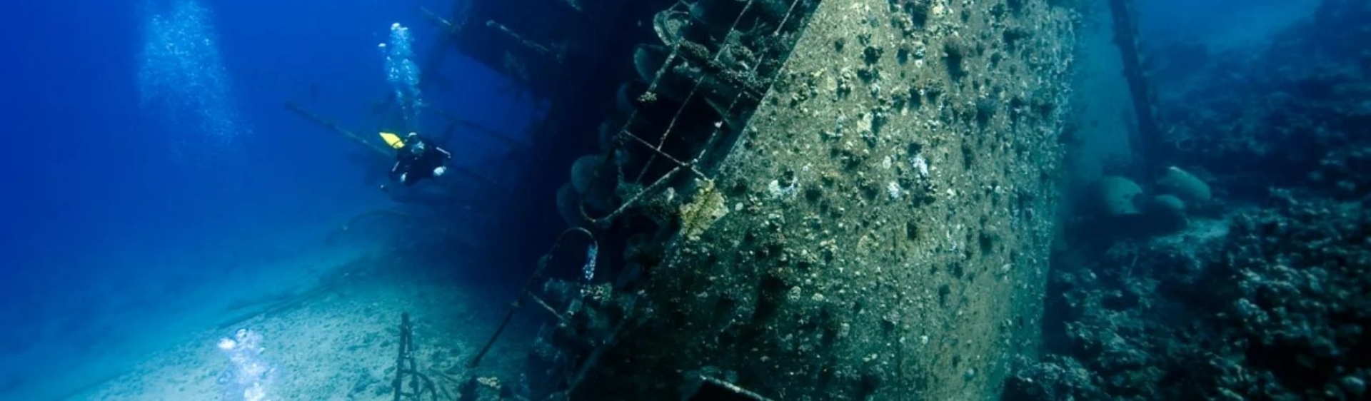
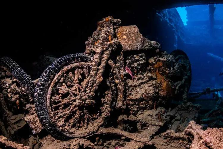
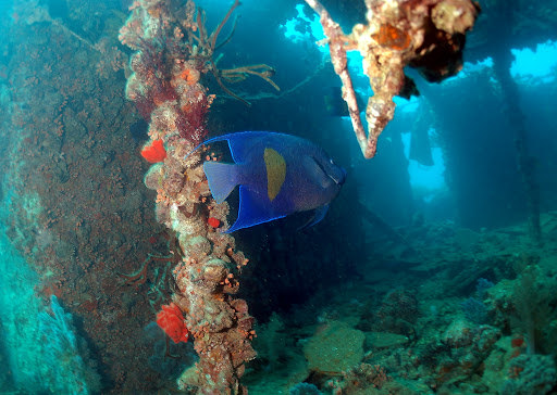
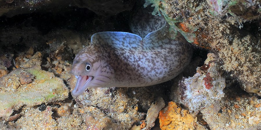
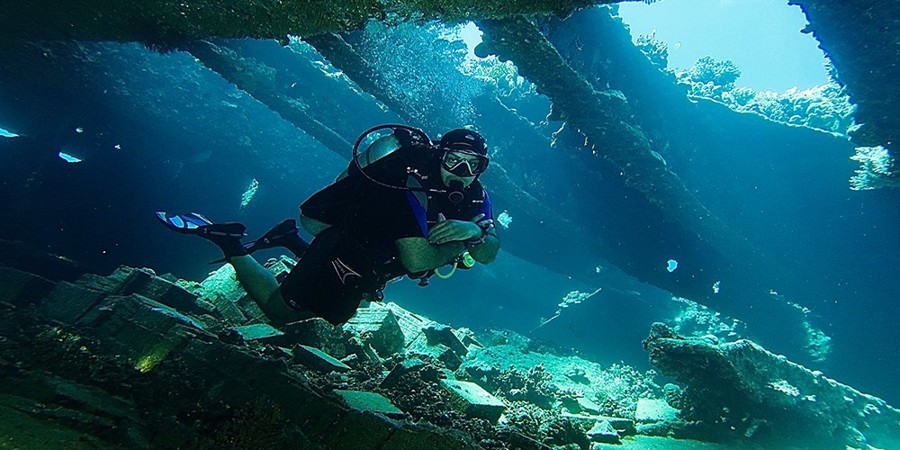
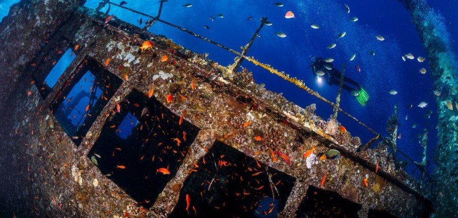
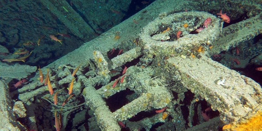
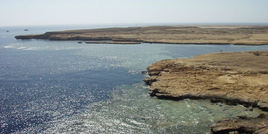
  • Abu Nuhas / Carnatic

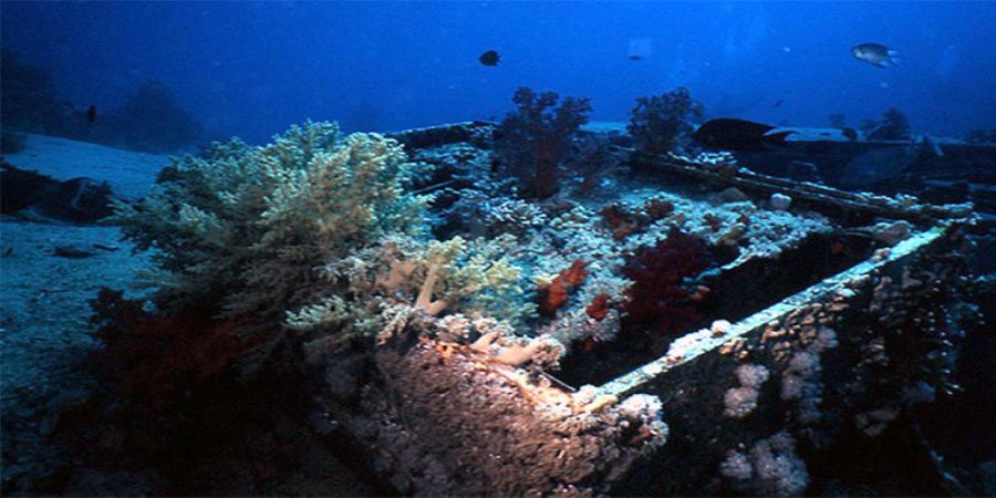
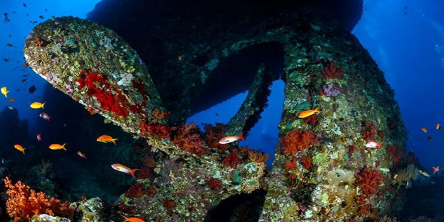
    The Carnatic, on a voyage from Liverpool to Bombay with 27 crew, 203 passengers, and a cargo of cotton, copper plates, and 40,000 pounds sterling in gold, ran aground on the reef Shab Abu Nuhas on the night of September 13, 1869. The ship initially remained on the reef, but broke apart and sank on September 15, despite various rescue attempts . Overconfidence in the ship's stability had a disastrous effect. Since the Carnatic had not been cleared and passengers and crew members were on board, the ship took 27 people down with it . The survivors first rescued themselves on Shadwan Island and were later recovered by the Sumatra. In October 1869, a helmet diver recovered most of the gold cargo as well as 700 copper plates. Several bodies were also discovered - one victim was still stuck in a porthole through which he had tried unsuccessfully to escape. 8,000 pounds sterling could still be in the wreck. No one has found them yet - perhaps they were secretly salvaged or disappeared under coral. The wreck was rediscovered in 1984 and has been a popular destination for Hurghada dive boats ever since. Since then, souvenir hunters have plundered it thoroughly. The Carnatic lies on its side at the base of the reef at a depth of 20 to 27 meters. In the middle the ship is badly damaged, bow and stern are well preserved. The wooden decks have rotted away so that it is safe to enter the interior. The hull is densely covered with stone and leather corals.

  • Abu Nuhas / Chrisoula

    After several previous owners, she finally changed to the shipping company Clarion Marine and was given the name Chrisoula K. Under this name she also made her last voyage, which took her to the area of the Abu Nuhas reef in the Red Sea on August 30, 1981 with a cargo of cheap Italian floor tiles. Due to a navigational error by the captain, the ship ran aground on the reef during the night of August 30 and sank. Today the wreck lies in an optimal position for divers at a depth between 5 meters and a maximum of 25 meters. The ship is in a slight inclination, the middle part is heavily damaged by the impact.

  • Abu Nuhas / Ghiannis

    For a long time the front half, which had run up on the reef, remained stationary and indicated the place of the accident, then it too sank and lay down on the port side. The aft half of the wreck lies somewhat inclined on the port side. Above the front of the quarterdeck rises the smokestack with the large letters "D". The "D" stands for the name of the shipping company: Danae. In front of the chimney is the bridge deck, behind it other spaces, a huge winch, the bollards, the intact railing, and even the frame that used to support a large awning was not damaged in the sinking. At the base of the funnel are narrow portholes leading into the engine room. The engines are an impressive sight with their long rows of cam arms, valves and pipes. The middle section of the ship resembles a junkyard, as iron girders are bent and torn, and the sides lie collapsed on the seabed. This area of the wreck is teeming with crocodile fish, scorpion fish and parrot fish. Some groupers have also made their home here.

  • Shaab Mahmud with Dunraven

    The interior of the lagoon is often visited by cruise ships, as it provides the necessary shelter for the night. Usually, the anchor is dropped on the sandy bottom inside the lagoon - near a narrow opening in the coral reef, the so-called Small Passage. This passage, which can be passed only by a dinghy, offers a great opportunity to see the beautiful coral reef outside the lagoon. Then a pleasant break inside the lagoon near the anchorage. During this dive hawksbill turtles can be encountered. In addition, you are sure to encounter mackerels and barracudas.

  • Dunraven

    Beacon Rock is a small reef that partially rises above the water surface, located 6.9 miles west of Ras Mohammed, and has a small lighthouse that marks the southernmost point of Sha'ab Mahmud. It was here that the English cargo ship Dunraven, which had mixed propulsion and had been built by the Mitchell & C. shipyard in 1873, sank in 1876 on its way to Bombay. The wreck, which lies inverted and separated into two parts at a depth of between 15 and 29.5 meters, was first discovered in 1977 by geologist Arye Keller and underwater cameraman Howard Rosenstein. The Dunraven was the subject of a memorable 1979 BBC documentary and subsequently became a classic dive site. Since the cargo consisting of wood and cotton bales was lost during the shipwreck and the ship caught fire, the wreck presents itself today as a large, almost empty cavern, into which one penetrates through three main openings on the stern, the middle section and the bow.

  • Ras Mohammed with Jolanda & Shark Reef

    The cape takes its name from its rocky peak to the east, whose contours are reminiscent of a male profile with a beard - the head of Mohammed - carved in stone. Ras Mohamed is one of the world's most famous dive sites and is located at the tip of Sinai. Two small reefs are connected by a vertical sloping wall.<br/>Close to Shark Reef, a little further north, is Anemone City, an vast, shallow reef zone with numerous sea anemones and their red sea anemone fish and three-spotted damsel fish. From Shark Reef, you can drift with the current along a steep wall that drops several 100 m to Jolanda Reef. The wall is completely covered with colourful corals. On the way to Jolanda Reef you reach a plateau with small boulders and coral islands. Once at the reef, you will see the scattered remains of the Yolanda wreck ,containerised sanitation facilities for the construction industry, now completely taken over by the life of the coral reef.

  • Jolanda

    Containers, toilets, bathtubs, wallpaper, boxes of whiskey and even a BMW 320 that belonged to the captain are spread all over the plateau. The ship, which partially rose above the water surface and was in an unstable position because the bow was vertically stuck in the bottom, was pushed by the waves to a depth of 50 meters in early 1987 and disappeared into the blue below during a violent sea storm on March 15 of the same year.

  • Blue Hole

    This enormous hole along the coast in the coral reef with a diameter of 50 to 65 meters, is located 10 km north of Dahab in the east of the Sinai Peninsula. The drop-offs reach depths of considerable 70 to 110 meters. The Blue Hole is a large hole in the reef top of the coastal fringing reef, which drops vertically to depths of 70 meters to 110 meters. It has a diameter of 50 to 65 meters. The reason why the Blue Hole is considered the most dangerous dive site in the world is because of a connection to the open sea, which is called an "arch" because of its shape. It extends from the bottom of the Blue Hole up to a depth of 55 meters. At its upper end it is only a few meters wide and about 26 m long. Also at the outer edge the reef forms an almost vertical drop-off, which continues below the "exit" of the Blue Hole as a steep slope down to several hundred meters depth.

  • Canyon

    Inside the canyon, depths range from 25 metres to its shallowest point (closest to the reef wall) to more than 50 metres. You must be an advanced diver to dive here. Technical divers can enter the canyon and follow it through a crack at 54-55 metres to the deepest exit.

  • Gabr el Bint

    Gabr el Bint means 'The Grave of the Girl' in Arabic. There are two dives possible here. The right side, also known as the dark side, features a steep wall that drops down to about 60m cut by numerous chasms, sandy ravines and overhangs. The drop-off is adorned with healthy table corals. The left side is a far more colourful featuring a virtual forest of gorgonians. Usually drop down to about 20-25m swimming along massive boulders protruding from the drop-off which attracts dense shoals of anthias and glassfish. Keep a good eye on the blue where you will see trevallies hunting on the shoals of fusiliers. After about ten minutes you will find some of the healthiest gorgonian fan corals in the Red Sea. Here you start to ascend to about 10m and cross the saddle then start to head back along a sandy ledge which parallels to the shore. The ledge is riddled with exquisite coral heads that attract numerous reef species, including swarms of anthias, scorpionfish, parrotfish, crocodilefish, surgeonfish, triggerfish, trumpetfish, stingrays and very often a turtle. At the end of the ledge usually is home to a shoal of black and white snappers and twinspot snappers hang here between 5m and 10m. One of the truly breathtaking dives in Dahab.

Golden Dolphin Safari World

English Deutsch 中文(简体)
up